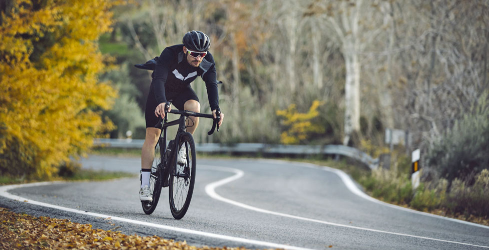
Cycling Ebbetts Pass Roads
Cycling Ebbetts Pass Roads offers many great places to ride between Murphys and Markleeville. Cyclists will never want for choices. We offer a sample here of great rides, working from west to east. On any of these rides, of course, you could just select to do a part of the ride rather than the entire distance.
For those preferring mountain bike trails, check out our section Ebbetts Pass Mountain Biking.
Death Ride
For information about the Tour of California Alps Death Ride over Ebbetts Pass, see The Death Ride Over Ebbetts Pass.
Bicycling Index
ANNUAL RIDES
Mr. Frog's Wild Ride
Riding the Wild Sierra
Ebbetts Pass Century Rides
LINKS AND SERVICE
Ebbetts Pass Cycling Events
Mr. Frog's Wild Ride - May 6, 2023
Murphys, California
Registration opens soon for the annual Mr. Frog's Wild Ride benefitting Feeney Park and youth sports in the area. Three routes
are offered.
55-Mile Ride This longer ride includes Sheep Ranch, Mountain Ranch, Calaveritas, and Angels Camp. Over 6,000 feet elevation gain, eight category 5 hills.
43-Mile Ride The route takes riders through Sheep Ranch, Mountain Ranch, Calaveritas, and Angels Camp. With 4,600 feet elevation gain, 7 category 5 hills, but about an hour shorter than the 55-mile ride.
21-Mile Ride A shorter loop with some steep bumpy roads. 1,600 feet elevation gain.
For more information see Mr. Frog's Wild Ride
Alta Alpina Challenge: Riding the Wild Sierra
June 29, 2024
Markleeville, California
Five Rides
- Wild Sierra Metric - 64 miles, course passes through Diamond Valley, Luther Pass, and Blue Lakes.
- Wild Sierra Century - 110 miles, course crosses Kingsbury Grade, the east side of Ebbetts Pass, and the west side of Monitor Pass.
- 5 Pass Challenge - 134 miles with 16,000 feet of climbing. Course passes over the east side of Carson Pass, and both east and west sides of Ebbetts and Monitor passes. /li>
- 8 Pass Challenge - 198 miles and 20,300 feet of climbing. Course passes over Kingsbury Grade, south side of Luther Pass, east side of Carson Pass, Blue Lakes Road, and both sides of Ebbetts and Monitor passes.
- Brush with Death - 87 miles and 12,000 feet of climbing, covering both sides of Ebbetts and Monitor passes.
All rides begin at Turtle Rock Park near Markleeville (Check website for any updates on the start location). The Alta Alpina Challenge: Riding the Wild Sierra is organized by the Alta Alpina Cycling Club.
For more information and online registration, see
Alta Alpina Challenge: Riding the Wild Sierra
TOP
Ebbetts Pass Century Rides - August TBA, 2024
Bear Valley, California
Four Rides
- Ebbetts Pass Century - 103 miles - Course: from Bear Valley to Markleeville on a new course. See their map for details.
- Bear Valley Metric Century - 67 miles (about 100 kilometers) - Course: Bear Valley, Spicer Meadow Reservoir, Ebbetts Pass, Bear Valley. Climbs: 7,400 feet
- Bear Valley Half Century - 51 miles - Course: Bear Valley, Spicer Meadow Reservoir, Pacific Grade Summit, Bear Valley. Climbs: 4,700 feet
- Stanislaus Quarter Century - 35 miles - Course: Bear Valley, Spicer Meadow Reservoir, Bear Valley. Climbs: 3,300 feet
For more information and online registration, see Ebbetts Pass Century
Ebbetts Pass Cycling Routes
Murphys - Avery Area Rides
Sheep Ranch Road - Highway 4
Distance and Difficulty: 19 miles for the loop, strenuous
Elevation Gains: 2000 feet in the first 10 miles
Route Type: Loop, Asphalt
Take Sheep Ranch Road out of Murphys, climbing for the first mile past Mercer Caverns, drop into the valley
at San Domingo Creek and then begin a steady climb, broken up only by a dip into Indian Creek. Summit just beyond
Timber Trails (mile 10). Retrace your route to Murphys, or glide down to Avery and follow Highway 4 back to Murphys.
Murphys Grade Road - French Gulch Road
Distance and Difficulty: 8.5 miles for the loop, difficult
Elevation Gains: 900 feet on the return 4 miles
Route Type: Loop, Asphalt
Follow Murphys Grade Road southwest out of Murphys to the lower end of French Gulch Road (3.5 miles). Then
return on the much less often traveled French Gulch Road back to Murphys.
Canyon View Road
Distance and Difficulty: 2 miles round trip, easy
Elevation Gains: 200 feet
Route Type: Partial Loop, Asphalt
From Hathaway Pines ride out Canyon View Road, enjoying the views of the Stanislaus River Canyon. The
road makes a small loop at its end.
Moran Road
Distance and Difficulty: 11 miles round trip, moderate
Elevation Gains: 800 feet in 5.5 miles
Route Type: Out and Back, Asphalt
Follow shady, historic Moran Road up from Avery along the side of Moran Creek. At mile 4 pass Fly In Acres
little lake and then Sequoia Country Club Golf Course. Turn around there if you like, because the last mile is
less appealing as it climbs up to meet Highway 4. Add a 5.5 mile (total) dogleg out Love Creek Road if
you choose, climbing 500 feet and stopping at the end of the paved road.
TOP
Arnold - Big Trees Area Rides
White Pines
Distance and Difficulty: 2 miles, easy
Elevation Gains: 200 feet on the return
Route Type: Loop, Asphalt
From Arnold follow Blagen down to White Pines, stop at the park and the Logging Museum, and then circle
back via Dunbar Road.
Big Trees State Park South Grove
Distance and Difficulty: 18 miles, strenuous
Elevation Gains: 1800 feet (800 on the way out, and 1000 coming back)
Route Type: Out and Back, Asphalt
From the main parking lot follow the South Grove Road to the picnic area and enjoy an hour or two of rest
by Beaver Creek before beginning the 1000-foot climb back up from the Stanislaus River.
TOP
Highway 4
Poison Spring to Big Meadow
Distance and Difficulty: 10 miles round trip, moderate
Elevation Gains: 100 feet, rolling terrain
Route Type: Out and Back, Asphalt
This is as close to level as any 5-mile stretch on the west side of Ebbetts Pass gets. Start at Poison Spring (9 miles east of Camp Connell). There's
a good place to park there off the road. Ride east over rolling terrain for 5 miles, passing Ganns, Liberty Vista Point, Cabbage Patch,
and Big Meadow. Turn around at the junction of Skyline Road. Or extend your ridge another 4 miles to Bear Valley, climbing another 500'.
Spicer Meadow Reservoir Road
Distance and Difficulty: 18 miles round trip, difficult
Elevation Gains: 800 feet going, 1000 feet on the return split between two sections
Route Type: Out and Back, Asphalt
Start at the Sno-Park where Spicer Meadow Reservoir Road leaves Highway 4. Ride downhill to the Stanislaus
River crossing (mile 3) and then climb 800' past Gardner Meadow before dropping down to Spicer Reservoir.
Bear Valley to Lake Alpine
Distance and Difficulty: 8 miles round trip, moderate
Elevation Gains: 550 feet
Route Type: Out and Back, Asphalt
The classic ride from Bear Valley up to Lake Alpine. Have lunch at Lake Alpine Resort or a picnic at Chickaree
Picnic Area. Then take a swim in the lake before returning to Bear Valley.
Advisory
At Lake Alpine the pavement narrows, making cycling more dangerous. Extra caution should be used when riding in the vicinity of Lake Alpine and especially beyond. At Lake Alpine there are sections of paved bike trails along the lakeshore. They make a good place for families to ride.
Bear Valley to Bear Valley Mountain Ski Area
Distance and Difficulty: 9.5 miles round trip, moderate
Elevation Gains: 1000 feet, 200-foot climb on the return
Route Type: Out and Back, Asphalt
Make this ride on its own or combine it with a Lake Alpine ride. Views from the road near the ski area
looking south toward the Dardanelles
are spectacular.
TOP
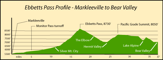
Markleeville to Lake Alpine
Markleeville to Silver Creek Campground
Distance and Difficulty: 24 miles round trip, difficult
Elevation Gains: 1000 feet spread over 12 miles
Route Type: Out and Back, Asphalt
The road from Markleeville follows the East Fork of the Carson River, offering wonderful views of the
canyon and surrounding peaks. Beyond the Wolf Creek turnoff, the road picks up Silver Creek. It is narrower here, but traffic is generally light. The ride is especially nice in the fall when the trees have turned.
Markleeville to Lake Alpine
Distance and Difficulty: 35 miles one way, very strenuous
Elevation Gains: 4200 feet in two main climbs going west, 2,300 feet going east
Route Type: Out and Back, Asphalt
This long ride is popular because of the challenge of the climb up Ebbetts Pass and the spectacular views from
the road on either side of the pass. From Markleeville the ride carries you 35 miles west on Highways 89 and 4 and up over 3200 feet to the summit of the pass and down to Lake Alpine. The descent on the west side includes a stiff 1000-foot climb out of Hermit Valley up over Pacific Grade Summit. Some riders prefer the reverse route, starting in Bear Valley.
The descent on the eastern side of Ebbetts Pass is very dangerous with sharp curves, no guard rails, and nearly vertical drop-offs. Extra caution!
TOP
Cycling on Sonora Pass and Carson Pass
Sonora Pass
Sonora Pass (Highway 108) to the south has more interesting cycling routes. Check out Sonora Pass, on our sister website, Sonora Pass Vacations.
Carson Pass
To the north is Carson Pass has beautiful roads for cycling. To see of list of suggested rides, visit another of our sister websites, Up and Over Carson Pass.
Cycling Services
Bear Valley Bicycles
1122 CA-4, Suite 2/3
Arnold, CA 95223
209.897.0326
Best Ride Ever
Arnold
(209) 795-0735
Bicycle repair shop
Mountain Pedaler Bicycles
352 S. Main Street
Angels Camp
(209) 736-0771
Road and mountain bikes, sales and service
Other Cycling Links
Bear Valley Bicycles
Steep Hill - Recreational Cycling: Markleeville, Ebbetts Pass, Monitor Pass
Alta Alpina Cycling Club - Alpine County