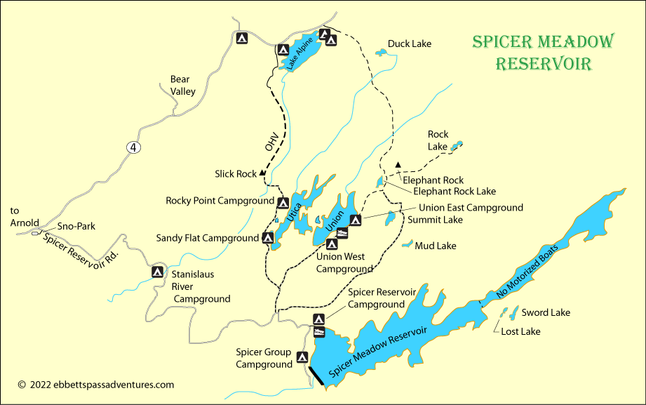
Spicer Meadow, Utica, and Union Reservoirs

Spicer Meadow Reservoir has long been a favorite destination for anglers, hikers, kayakers, and campers. Only a short drive away are beautiful Utica Reservoir and Union Reservoir with more opportunities for fishing, camping, and kayaking.
The lakes are accessed via 9-mile-long Spicer Meadow Reservoir Road, which leaves Highway 4 about 4 miles west of Bear Valley. Utica and Union are at about 6,800 feet elevation, Spicer a little lower at 6,400. The road is closed in the winter by snow, but a Sno-Park located at the junction with Highway 4 provides a winter launching site for snowmobilers and cross-country skiers into the area.
Spicer Meadow Reservoir
Spicer, Utica, and Union reservoirs (along with nearby Lake Alpine) are all part of a linked storage system which provides drinking water and hydroelectric power. New Spicer Meadow Reservoir, which replaced the older reservoir in 1989, is the largest of the lakes with 2000 surface acres. Utica covers 233 acres and Union, 218. Most of the water from the two smaller reservoirs is diverted into Spicer before being released back into the Stanislaus via Highland Creek.
Boating and Fishing
Boating
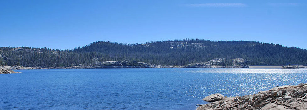
Spicer Meadow Reservoir has the best boating facilities of the three lakes. There is a concrete launch ramp and parking area for trailers. Boats on Spicer are limited to 10 MPH. The lake has 22 miles of shoreline, several islands, and numerous inlets. The upper part of Spicer is limited to non-motorized boats.
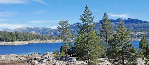
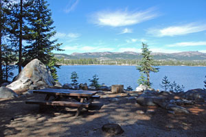
Union Reservoir (shown right or above) has an unimproved boat ramp suitable for small fishing boats. The speed limit there is 5 MPH. Although Utica Reservoir has no officially designated ramp, car-top boats can be launched there. Kayaks, canoes, and paddleboards are the most popular crafts on the two smaller reservoirs.
Kayaks, canoes and paddleboards can be rented from companies such as Sierra Nevada Adventure Company in Arnold and Bear Valley Adventure Company in Bear Valley.
Fishing
Expect good fishing in all three reservoirs and in the nearby streams. Spicer Meadow Reservoir is stocked with Eagle Lake rainbows and Kamloop trout. German browns are in the lake, but rarely caught. Trollers at Spicer do well with needlefish, Sparklefish, or Goldeneyes, working the area from the ramp to the dam. Another good spot for boaters is along the rock walls. Float tubes have plenty of success too, staying close to shore to avoid the wind. From the shore, bait fishermen report pink PowerBait works well, along with nightcrawlers and salmon eggs. Spin casters favor Rapalas and Kastmasters.
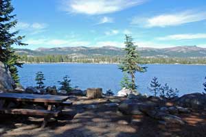
Union and Utica (shown left or above) reservoirs are good fishing destinations also. Union is stocked with rainbows, while Utica is home to native trout which are a little harder to catch. Both lakes also have brown bullhead catfish which can be caught easily from the banks. The best fishing in Union is reportedly at the western end of the lake near the boat ramp.
Camping
Stanislaus River Campground
Stanislaus River Campground is on the bank of the North Fork of the Stanislaus River at an elevation of 6,200 feet, 3 miles from Highway 4. A nearby sandy beach area is located at the southern end of the campground. The campgrounds has 25 sites for tents or RVs, hand pumped water, and vault toilets. Camping fees are $12 per night.
Spicer Reservoir Campground
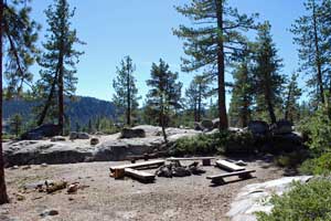
Spicer Reservoir Campground located at an elevation of 6,400 feet near Spicer Meadow Reservoir. It is 9 miles from Highway 4 over a good paved road. The campground has 43 sites for tents or RVs, with piped water and vault toilets. Camping fees are $24 per night.
Spicer Reservoir Group Campground
Spicer Reservoir Group Campground is located at an elevation of 6,400 feet along the shore of Spicer Meadow Reservoir. The group camp holds a maximum of 60 people. There are 7 group sites for tents or RVs. The campground has piped water, a covered group cooking and eating area, vault toilets and a campfire area. $140 per night.
Reservations required: Reservations for the group camp are taken beginning at 9:00 am on Jan. 1 of each year. Contact Sierra Recreation Managers for group camp reservations at (209) 296-8895. Reserve in early January for best availability.
Union and Utica Reservoirs
Union and Utica reservoirs are located side by side 2 miles off the Spicer Reservoir Road. At one time they were areas for dispersed camping, but recently developed campgrounds have been established around the lakes.
Directions: Spicer Reservoir Road leaves Highway 4 twenty-two miles east of Arnold or six miles west of Lake Alpine. Follow the road to Spicer Reservoir Road 8½ miles to the turnoff to Union and Utica reservoirs. Another 2 miles leads to either lake. Vault toilets are provided along with unimproved launch ramps
Fees: $16 per night
Union and Utica Campgrounds
- Union West - 18 walk-in campsites
- Union East - 11 campsites, RVs up to 27'
- Utica's Sandy Flat - 11 walk-in campsites
- Utica's Rocky Point - 12 walk-in campsites
- Granite Gulch Group Campsite: $48 per night
For more information about camping at Spicer, Union and Utica reservoirs, see
Spicer Meadow Reservoir Campgrounds.
Hiking
Elephant Rock Lake to Lake Alpine
Distance: 4 miles one way, mountain trail
Elevation Changes: 600 feet gain and some downhill going toward Lake Alpine
Drive out to the end of the Summit Lake Road off Spicer Meadow Reservoir Road. Hike from Elephant Rock Lake north, crossing the Stanislaus after a little more than a mile. At about 3 miles pass Duck Lake on your right. Then climb a ridge and drop to the trailhead at Lake Alpine. (Still another 1.3 miles to the Lake Alpine Resort)
Elephant Rock Lake to Rock Lake
Distance: 1.8 miles one way, mountain trail
Elevation Changes: 800 feet gain going out
Drive out to the end of the Summit Lake Road off Spicer Meadow Reservoir Road. Hike from Elephant Rock Lake past Elephant Rock and up to Rock Lake. For an easier hike only go as far as Elephant Rock, a half mile each way over fairly level terrain.
Around Utica Reservoir
Distance: 6 miles one way, cross-country
Elevation Changes: 100 feet up and down
There is no established trail around Utica Reservoir, but a fairly obvious use trail circles the lake. Do all or part of the convoluted shore line. Bring your fishing rod and fresh water. Expect to take longer than you might walking on an established trail.
Spicer Dam to Dome Rock
Distance: 6.5 miles one way, mountain trail
Elevation Changes: Climb 700 feet, drop 600 feet, climb 800 feet to summit of Dome Rock
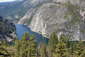
A trip with spectacular views of the Dardanelles and the Middle Fork of the Stanislaus River Canyon by Donnell Reservoir (shown right). Best done as an overnight backpack trip. Since it is in the Carson-Iceberg Wilderness, you will need a wilderness permit to camp. From the trailhead at the dam at Spicer Reservoir, follow the trail
south up over the saddle by Whittakers Dardanelle. Then drop into Wheats Meadow, a possible camping spot. To reach Dome Rock, continue south to Horse Meadow.
Views of the Middle Fork of the Stanislaus can be gained from a low summit just south of Horse Meadow. There is no trail up Dome Rock. It should only be attempted by experienced cross-country hikers or mountaineers. The summit of the rock is 2,700 feet above the canyon below.
Spicer to Sand Flat
Distance: 5.5 miles one way, mountain trail
Elevation Changes: Drop 1000 feet going out
Start at Spicer Reservoir and hike through Corral Meadow and then make then steep descent into the Stanislaus River Canyon, arriving there at Sand Flat. There is a bridge, so you could cross and hike up to Highway 4 at Big Meadow for a pick-up (2.3 miles, 800-foot climb). Shorten this hike by beginning at Gardner Meadow on the Spicer Reservoir Road (2.5 miles to Sand Flat, 900-foot drop).
OHV Routes
Slick Rock Trail: Utica Reservoir to Lake Alpine
The 3.5-mile Slick Rock trail begins at Utica Reservoir and runs up to Lake Alpine. Follow the road out to near its end on the west side of Utica where there is a good staging area. The route leads north from Utica and up across polished granite outcroppings. The hardest section is at Slick Rock, also referred to as the Ladder - a stepped portion of smooth granite. Another challenging area is near the Duck Creek bridge.
For more information about OHV routes around Ebbetts Pass, see
Ebbetts Pass OHV.
Snowmobiling
The snowmobile trail begins 1/4 mile from Highway 4 at the Spicer Reservoir Road Sno-park ($5 parking per day). The route follows the roads to Union and Utica Reservoirs, Summit and Elephant Rock Lakes, or the Spicer Reservoir Power House. Very experienced riders may try the un-groomed route along Slick Rock Road to access Lake Alpine.
For more information about snowmobile routes around Ebbetts Pass, see
Ebbetts Pass Snowmobiling.