Explore the High Country around
Ebbetts Pass

Highway 4 crosses Ebbetts Pass at 8,735 feet in elevation. The drive across the pass offers motorists magnificent panoramic views of the high Sierra, from the spectacular Folger Peak ridge on the west side of the summit to the breathtaking drop into the Silver Creek canyon on the east.
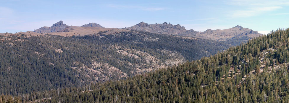
Those who pause to explore the open high country on either side of the pass are rewarded with two beautiful clusters of lakes - Highland Lakes (shown below) on the west side of the pass and the cluster of Kinney Lakes on the east. At the top of the pass runs the Pacific Crest Trail, leading away north and south into the wilderness.
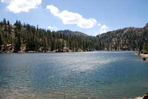
Highland Lakes
Highland Lakes
The two Highland Lakes rest at an elevation of 8,600 feet at the foot of Folger Peak and at the edge of the Carson-Iceberg Wilderness. A 6-mile dirt road leads from Highway 4, just a mile west of Ebbetts Pass, to Highland Lakes. The road fords a stream which may present a challenge early in the season, but late in the summer it is easy to cross. The lakes spread across a wide, alpine valley. The larger of the two lakes feeds its water north into the Mokelumne River drainage, while the smaller lake sends its water southwest to Spicer Reservoir and the Stanislaus River system.
Hiking and Equestrian Trails
Highland Lakes to Asa Lake 2.5 miles, gentle ups and downs. Asa Lake is on the Pacific Crest Trail.
Tryon Meadow to Milk Ranch Meadow 2 miles, mild elevation changes. Start at Tryon Meadow
(1 miles north of the lakes) and hike to the meadow.
Highland Lakes to Spicer Reservoir 8 miles, 2000-foot drop in elevation. Camp at the upper end of Spicer and then make the return hike, or continue the next day another 5 miles to a pick-up at the Summit Lake parking lot.
Highland Lakes to the Clark Fork 9 miles, 2300-foot drop in elevation. Hike to the Clark Fork of the Stanislaus River off Highway 108.
Camping and Fishing
There are two campgrounds near Highland Lakes, Bloomfield Campground along the Mokelumne River just a mile from the highway, and Highland Lakes Campground located at the lakes. Neither campground takes reservations. Bloomfield has piped water, but Highland does not.
For complete information about camping around Highland Lakes, see
Highland Lakes Campgrounds.
Fishing in Highland Lakes is good for brook trout. The maximum boat speed on both lakes is 5 MPH, and the Forest Service discourages the use of gas-powered boats there. Float tubes would work well on the lakes as long as the wind remains calm. There is easy access to the shores all around the lakes and few trees or bushes to inhibit casting.
Kinney Lakes
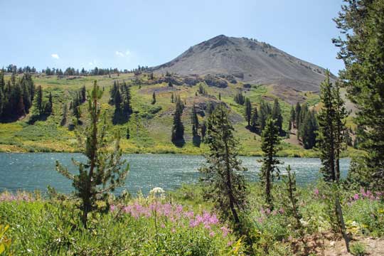
Kinney Lakes are a trio of reservoirs on the eastern side of Ebbetts Pass at the headwater of Silver Creek. The lakes are at an elevation of 8,500 feet and become accessible as soon as the highway opens, usually about mid-May, although ice may still cover the lakes until June. Kinney Reservoir (shown right) sits beside Highway 4 and as a result attracts a good number of anglers. The other two lakes are about a mile back from the road, accessible by hiking out a dirt road or following the Pacific Crest Trail north from the pass.
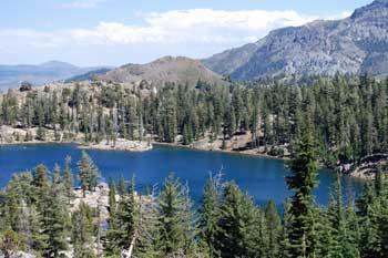
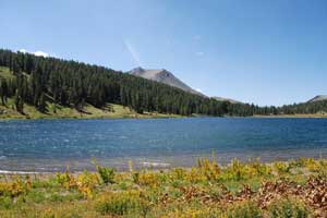
Hikers on the Pacific Crest Trail often camp on the western side of the upper lake, but Lower Kinney Lake (shown left) receives few visitors. There are no developed campgrounds near the lakes. Fishing in the reservoir next to the road is good for both rainbow and brook trout. The more remote two lakes have Lahontan and brook trout. The lakes can all be fished from float tubes.
Hiking and Equestrian Trails
Lower Kinney Lake 1-mile, mild elevation gain. Park near the dam at Kinney Reservoir, cross the dam and follow the dirt road/trail that continues beyond the dam through a meadow and up to Lower Kinney Lake. The same route continued will take you to the upper lake.
Upper Kinney Lake 1.6 miles, virtually level. Park in the little turnout just east of Ebbetts Pass where a Pacific Crest Trail sign marks the beginning of the trail leading north (different from the large PCT parking lot). After a quarter mile on the trail you will look down on Kinney Reservoir and after 1.6 miles reach the upper lake.
The Pacific Crest Trail
From the summit of Ebbetts Pass you can follow the Pacific Crest Trail either north or south. There is a trailhead parking lot and restroom one half mile east of the pass.
North on the Pacific Crest Trail: Hiking north on the trail carries you past the Kinney Lakes and along the rugged volcanic slopes of Reynolds and Raymond peaks. Great vistas of the mountains and valleys to the east open up along the way. Continuing 10 miles on the trail would take you to Wet Meadows Reservoir and the Sunset Lakes (and roads) close to Blue Lakes off Carson Pass. Elevation changes along the trail are mild.
South on the Pacific Crest trail: Hiking the southern direction on the trail involves more significant elevation changes, climbing and dropping over a thousand feet in the first 6 miles. Noble Lake is 3.5 miles south on the trail and Asa Lake is another 3 miles beyond that. You could hike to Asa Lake and then take a lateral trail another 2.5 miles over to Highland Lakes (8-9 miles total).
High Sierra Trails
A Backpacker's Guide to the
Most Spectacular Trails
in the Sierra Nevada